Check out this really cool research expedition blog, Greenland’s Frozen Coast Expedition, from WHOI research scientist Ben Harden.
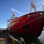
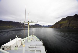 On 26 July, 2012 our ocean-science party, with members from Iceland, Norway, Germany, the Netherlands, and the United States, will board the northbound British Royal Research Ship James Clark Ross in Reykjavik, Iceland for a thirty-day expedition along the East Greenland Coast to the High-Arctic island of Spitsbergen. We’ll need to come close aboard that fantastically wild Greenland coast in order to understand this component of the vital avenues of circulation in Arctic waters—on which world climate stability depends. This team, aboard other research vessels, has studied other Arctic avenues, out in the Iceland, Irminger and Greenland Seas, but this time we’re going much farther north, into the ice. That’s why Chief Scientist Robert Pickart chose the Ross. She’s an icebreaker—within certain limits.
[vimeo]http://vimeo.com/46482870[/vimeo]
28th July 2012
It’s 1500 on Friday the 27th of July, a beautiful, cool, and cloudless afternoon in Reykjavik, Iceland. The ship’s crew and officers, the scientists, technicians and their specialized equipment—all are aboard now, and the James Clark Ross is ready for sea. The harbor pilot has joined the Captain and Second Mate on the bridge.
It’s thick o’ fog this morning. With its perpetually cold water and warmer air, the Arctic is famous for profuse fog. Sheets of it, like soft rain, are wafting across the decks in the light breeze. Peer into the murk for a time and you begin to see things, a whale languidly rolling, that black steel bow on a collision course, the Flying Dutchman. Fog anxiety must have stripped years from the lives of Arctic mariners in the centuries before radar. But in a way the relationship between mariners and fog is quite like that between oceanographers and oceans. Geologists, botanists and biologists, even astronomers can, if with magnification, see their subjects, but not oceanographers. They can see the surface, but that’s as nothing. The average depth of the North Atlantic is 12,000 feet, and there’s a lot going on down there essential to the science. No, oceanography requires imagination to see that which cannot be seen.
A professional scientist might devote his/her entire career to understanding a single current, and the language of the science can seem pretty esoteric, not to mention the tools required to measure a current running thousands of meters beneath the surface. However, ocean currents matter a great deal to the rest of us, even if we’ve never heard of them, because they transport heat from where there is too much—the tropics—to where there is too little—the high latitudes—and vice versa. By circulating, currents moderate world climate. And without their gift of moderation, vast swaths of Earth’s surface would be rendered uninhabitable, either sweltering hot or frozen solid.
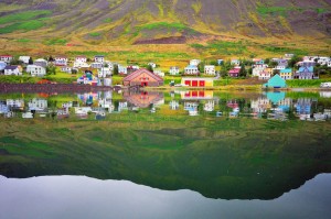 And that brings us to the other fundamental oceanographic principle we need to grasp in order to understand our purpose here in the foggy, cold Denmark Strait: the identity of water masses. As they course through the depths, currents retain a distinguishable fingerprint in the form of temperature and salinity. By measuring both, scientists can follow the water wherever it flows. For example, in 2008 in these same waters aboard a different ship, Bob Pickart, our chief scientist then and now, called me to his computer displaying a cross section of the water he’d been measuring near the mouth of a fjord well above the Arctic Circle on the east Greenland coast. The common program he used showed various water masses in the Greenland Sea in different colors, and he pointed to a mass of “yellow” water.
31st July 2012
I love life aboard research vessels, particularly in the Arctic. I enjoy every aspect, the rational division of responsibility, the esoteric language of the science and the sea, the practiced professional competence of the scientists, technicians, and mariners, the creative self-sufficiency to make things work and to fix them when they don’t. It’s a pleasure to watch. And then there is the social component, the sprawling conversations after dinner in the lounge, for heaven’s sake. The quarters are close, and everyone’s on their best congenial behavior, as they must be. Those who can’t be have probably been asked to find another line of work, though I’ve never met anyone at sea I wasn’t proud to call shipmate. Plus, this is a truly international group, Icelandic, Dutch, Norwegian, German, and American, wide-ranging in age and life experiences. And then there are the British officers and crew, who, if accents were the criteria, would be from about six different countries. Only now, three days into the cruise, can I understand (most of) them.
I’ve never sailed on a British ship before. James Clark Ross is clearly a fine one, and she brings certain surprising amenities such as three-course meals described in leather-bound menus and served on spotless tablecloths by a gentleman named Tom as if in a real restaurant. The food, which has been excellent, is cooked by, among other caring folks, an Irishman called, uh, Paddy. One could grow used to this sort of civilized seafaring. And though I probably shouldn’t risk jinxing us by mentioning it, even the weather—flat seas, light winds, and, at this writing, bright sun—has contributed brilliantly to the sweet quality of life. Even now, people appear on deck in shorts and tee shirts eighty miles north of the Arctic Circle. Seems unnatural. Can’t last,…can it?
Now this isn’t to say people have been idle or grown soft in the face of luxury. The science work began two days ago and now proceeds around the clock. Three watches consisting mostly of graduate students, some on their first cruise, operate a basic oceanographic instrument called the CTD, for conductivity-temperature-depth. It measures that all-important water fingerprint of temperature and salinity as well as current velocity, and it captures water samples from predetermined depths.
Leave a Reply