The North Carolina Sea-Level Rise Assessment Report prepared by the N.C. Coastal Resources Commission’s Science Panel on Coastal Hazards was published in March 2010. The report immediately attracted the attention of real estate investors and coastal development lobbying groups like “NC 20” that responded with anti-science propaganda like this (PDF). These groups successfully lobbied the state legislature to declare that coastal communities should only prepare for sea level rise this century of eight inches, which is lower that the rate most of North Carolina is already experiencing.
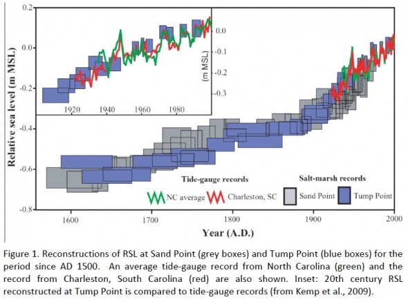
Past sea level rise: After a basic introduction to what “sea level rise” is and how it is measured, the report describes the empiral findings of several studies of past sea level rise in North Carolina (Horton et al. 2009, Kemp et al. 2009, Zervas 2004, see references below). State sea level rise averaged ~ 5mm/year from 12,000 BP (Before Present, “Present” being 1950) to 1mm/year in modern times. This rate is consider the current local “background” or natural sea lever rise caused by glacial isostatic adjustment. Except for a brief increased to ~2mm/year during the little ice age, the rate remained constant until the 20th century, when it increased to about 3.2 mm/year (12.6 inches/century). Finally, eight tide gage stations indicate the recent sea level rise has varied from ~ 2mm/year in the southern part of the state to nearly twice that rate in the north, e.g., 4.3 mm/year or 17 inches/century in Duck, near the Virginia border (see Table 1).
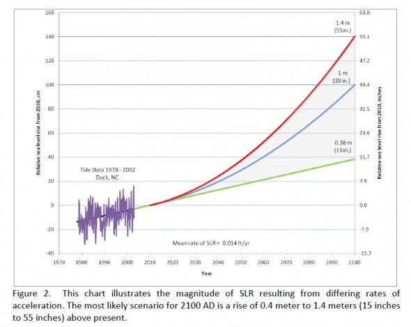
Future sea level rise: Next, as requested (see the panel’s charge below) the panel cautiously projected some of the possible scenarios of future sea level based on different degrees of sea level rise acceleration. Globally, sea level rise is known to be accelerating (also see here) and expected to accelerate further due to greenhouse gas emissions and global warming, and more directly to the loss of ice mass from Greenland and Antarctica.
..based on multiple indicators suggesting that global climate is warming, the Panel believes that an acceleration in the rate of SLR is likely.
Confidence levels and margins of error are not calculated for the individual rate curves because the curves are considered to be the upper and lower boundaries of sea level over the next 90 years. It is important to understand that the curves were generated using a constant acceleration rate to reach the selected endpoints derived from the literature, and are not projections of actual sea level at specific future dates. As a consequence, it is not accurate to interpolate quantities of sea level rise for specific years since we do not know whether RSL acceleration will be constant over the next 90 years. The curves are primarily intended to illustrate the expectation of increased acceleration.
The Science Panel does not believe, based on the data available at this time, that it is appropriate to attempt to quantify confidence intervals or margins of error beyond those inherent in the chosen scenarios, as informed by the published literature. Nevertheless, the Science Panel is confident that the curves presented constrain the plausible range of sea level by 2100 as accurately as is possible at this time.
The panel’s projections were based on the current science about sea level rise and climate change and are very much in line with the broad and deep consensus within the scientific community. The panel did not argue that any of the scenarios were more or less likely than others; they simply reported the probable range of sea level rise by 2100. They did not rule out lower sea level rise or far higher sea level rise, both of which are possible. Finally, the panels sea level rise forecast for North Carolina is concordant with what has been forecasted globally:
 Projection of sea-level rise from 1990 to 2100, based on IPCC temperature projections for three different emission scenarios. The sea-level range projected in the IPCC AR4 for these scenarios are shown for comparison in the bars on the bottom right. Also shown in red is observed sea-level (Vermeer and Rahmstorf 2009).
Panel background and charge: The panel included regional and international experts on sea level rise and coastal geophysics from many of the state’s most esteemed scientific institutions, including UNC-CH’s Institute of Marine Sciences, UNCW, NC State, the US Army Corps of Engineers, East Carolina University, and Western Carolina University.
The N.C. Coastal Resources Commission’s (CRC) Science Panel on Coastal Hazards was invited by Division of Coastal Management (DCM) staff to provide input into DCM’s sea-level rise (SLR) initiatives. The Science Panel offered to prepare a report, based on a review of the published literature, of the known state of SLR for North Carolina. The CRC and DCM asked the Science Panel to provide the best available information on the following questions:
1. An explanation of how SLR is measured: globally, and at the state and regional scales
2. Relative SLR ranges for different sections of the North Carolina coast, as appropriate to account for regional differences
3. Relative SLR ranges for North Carolina expressed in time slices for the years 2025, 2050, 2075, and 2100
4. Relative SLR rate curves for North Carolina through 2100
5. A discussion of the confidence level or margin of error for the reported ranges and rate curves
6. Recommendations as to what needs to be done for improved SLR monitoring in the State of North Carolina
7. Recommendations as to how frequently the State of North Carolina should update its projected SLR ranges and rates
The Science Panel has prepared this report in response to the CRC’s request, and has included a recommendation regarding how much SLR the CRC should be planning for by 2100. This report was researched and prepared by the Science Panel and six additional individuals who were selected because of their relevant expertise.
This report synthesizes the best available science on SLR as it relates specifically to North Carolina. The study of sea level change is inherently more accurate in revealing historic changes than in making predictions of the future. There is abundant research on historic sea level changes for North Carolina, but to date this data has not been synthesized into a form that can be used to inform policy and planning.
The intent of this report is to provide North Carolina’s planners and policy makers with a scientific assessment of the amount of SLR likely to occur in this century. The report does not attempt to predict a specific future rate or amount of rise because that level of accuracy is not considered to be attainable at this time. Rather, the report constrains the likely range of rise and recommends an amount of rise that should be adopted for policy development and planning purposes.
References
The North Carolina Sea-Level Rise Assessment Report (PDF)
Horton, B.P., Peltier, W.R., Culver, S.J., Drummond, R., Engelhart, S.E., Kemp, A.C., Mallinson, D., Thieler, E.R., Riggs, S.R., Ames, D.V., and Thomson, K.H. 2009. Holocene se-level changes along the North Carolina coastline and their implications for glacial isostatic adjustment models. Quaternary Science Reviews, 28: 1725-1736.
Kemp, A.C. (doctoral thesis, 2009). High resolution studies of late Holocene relative sea-level change (North Carolina, USA).
Kemp, A.C., Horton, B.P., Culver, S.J., Corbett, D.R., van de Plassche, O., Gehrels, W.R., and Douglas, B.C., 2009. Timing and magnitude of recent accelerated sea-level rise (North Carolina, USA). Geology 2009 37: 1035-1038.
Kemp, A.C., Horton, B.P., Corbett, D.R., Culver, S.J., Edwards, R.J., van de Plassche, O., 2009. The relative utility of foraminifera and diatoms in reconstructing late Holocene sea-level change in North Carolina, USA. Quaternary Research 71 (2009) 9-21.
Zervas, C. 2004. North Carolina bathymetry/topography sea level rise project: determination of sea level trends. NOAA Technical Report NOS CO-OPS 041.


Leave a Reply